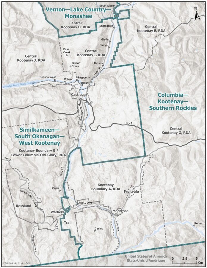
The City of Trail will join a mostly East Kootenay federal riding under the final proposal tabled by the electoral boundaries commission.
The original proposal, released last year, would have left the South Okanagan-West Kootenay riding largely unchanged, except for adding Keremeos and splitting part of Penticton off into a neighbouring riding.
Following public feedback, the commission came back with a much different plan, that called for the West Kootenay to be split among three ridings.
They suggested South Okanagan-West Kootenay, which presently includes most of the West Kootenay plus all of the Boundary and parts of the Okanagan be reconfigured to take in the Similkameen and renamed Similkameen-West Kootenay.
The Slocan Valley and Arrow Lakes would be moved to a new riding called Vernon-Monashee that would also include portions of the central and north Okanagan.
The Beaver Valley and some rural areas around Castlegar including Tarrys, Thrums, and Brilliant would be moved to the East Kootenay riding, which already includes Nelson, Salmo, and Kaslo. Presently known as Kootenay-Columbia and represented by Conservative Rob Morrison, it would be renamed Columbia-Kootenay-Southern Rockies.
The latest, and final, proposal followed objections from sitting South Okanagan-West Kootenay MP Richard Cannings and the Regional District of Kootenay Boundary.
The commission decided to let the rural Castlegar areas remain in what will be known at Cannings’ suggestion as Similkameen-South Okanagan-West Kootenay. However, they didn’t budge on the Slocan Valley and in addition to moving the Beaver Valley to Columbia-Kootenay-Southern Rockies, they have now included the City of Trail in that riding. However, Rossland and Warfield will be in Similkameen-South Okanagan-West Kootenay.
In a rationale published on its website, the commission said “in this complicated region, the vast Kootenays-Boundary Country area posed its own challenge by reason of geography.”
“In addressing Mr. Cannings’s objection, the commission has given detailed consideration to the alternatives available that will keep the populations of the electoral districts affected by the issue roughly level while strengthening some connections between communities closely associated with each other, as suggested by Mr. Cannings,” they wrote.
The changes are expected to become official in September and the new electoral map will be used in the next general election.
The purpose of the electoral redistribution exercise is to keep each riding to a similar population, to ensure similar representation.
Trail mayor Colleen Jones said the changes caught her off guard.
“I was a little confused because Trail was never part of the move,” she said. “We were trying to keep Beaver Valley together with Trail, Warfield, and Rossland, so we were a bit surprised.”
She said they “put up a pretty good campaign” to keep the Beaver Valley with the rest of Greater Trail, but in the end the area will still be split, just with a different dividing line.
She added it’s hard to know what the impact of the change will be, but one of her key concerns is where the local constituency office will be.
Cannings, whose South Okanagan-West Kootenay riding presently includes Penticton, Trail and Rossland, has maintained an office in Castlegar. However, Rob Morrison, who represents Kootenay-Columbia, has an office in Cranbrook but not one in West Kootenay.
“It’s a pretty big area to cover with the new boundaries,” Jones said. “We have a good relationship with the communities in the West Kootenay and it seems funny that we’re going to the [East Kootenay], but it’s something we have to get used to.”
Jones is scheduled to discuss the changes with Cannings on Friday. She expects they will be final.


