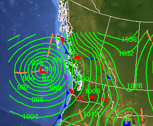
West Kootenay communities can expect to see more moisture and snow this week resulting from the bomb cyclone making its way through coastal B.C.
On Tuesday evening, the bomb cyclone hit the coast of Vancouver. According to Environment Canada, several Island communities experienced winds of over 100 km/h, with northern communities seeing peak winds of 170 km/h.
Meteorologist Brian Proctor says the activity associated with the cyclone is confined mostly to the coast at this point, but he warns that there will be associated moisture likely to produce more snow and rain in the West Kootenay region over the coming days.
“It’s likely to produce some snow, maybe mixed with rain, or rain in some of the valley bottoms this afternoon and continue through overnight Wednesday into Thursday before gradually easing off.” said Proctor.
“We’re looking at snowfall amounts of around 10 to 20 centimetres through that period, but in general terms, it will be more of a typical late-fall event with snow. The mixed rain at the valley bottoms will be the predominant influence factor that we’re going to see over the West Kootenays.”
Proctor says another large weather system expected to hit B.C. on Friday is forecast to affect portions of the province into Saturday, but by next week, weather patterns should settle.
“I would think through the end of the weekend into the start of the upcoming workweek, it should be a much more typical, less chaotic pattern in terms of weather systems coming in and impacting the province.”
Be the first to know! Don’t miss out on breaking news and daily updates in your area. Sign up to MyKootenayNow News Alerts.


